
Very excited to start a new weekly series with our friends at UpstateWeather.com! Each week UpstateWeather will bring their expertise and give us a seven day look at what we should expect from Mother Nature. If severe weather warrants, we will definitely bring you weather updates as needed.
Here’s this week’s Upstate Weather Forecast
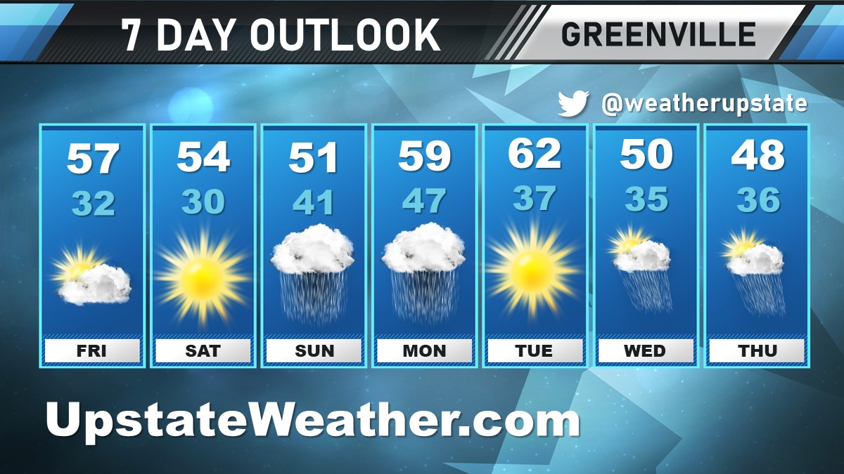
UpstateWeather.com 7 Day Outlook for #yeahTHATgreenville
ENJOY THE SUN THIS WEEKEND AS IT WON’T LAST
High pressure builds for the weekend, which will lead to dry conditions and plenty of sunshine along with temps near or just below normal. Friday will start with some clouds, but sunshine will win out in the afternoon as it returns this weekend. Seasonable for this time of year, we’ll see highs in the mid to upper 50s and lows in the 40s by Sunday. Rain moves in late Sunday evening.
EXPECT WIDESPREAD RAIN NEXT WEEK
Next week, expect widespread rain with a system that rolls through the area Sunday overnight into Monday. It will be a warmer system than normal, for this time of year, so no chance of wintry mix. Put the snow shovel back in the garage. Heavy showers possible during the day Monday (up to 80%). We’ll see sun again on Tuesday, but get the rain jacket back out for Wednesday and Thursday. Temperatures will be generally above normal Monday and Tuesday. We’ll see highs nearing 60 on Tuesday and lows in the mid to upper 30s throughout the week.
ON THIS WEEKEND IN 1985
On January 21st, 1985, Kershaw recorded a minimum temperature of -4°F, the coldest temperature on record in Lancaster County, SC.
UPSTATE, SC FORECAST:
Click here to see the UpstateWeather.com Forecast Center page.
CONNECT
Visit UpstateWeather.com and follow on Twitter @weatherupstate


