Videocast: Storms Today, Tropical Rain Next Week
Videocast: Storms Today, Tropical Rain Next Week

Updated: 11:47 AM EDT Aug 20, 2020
Show Transcript
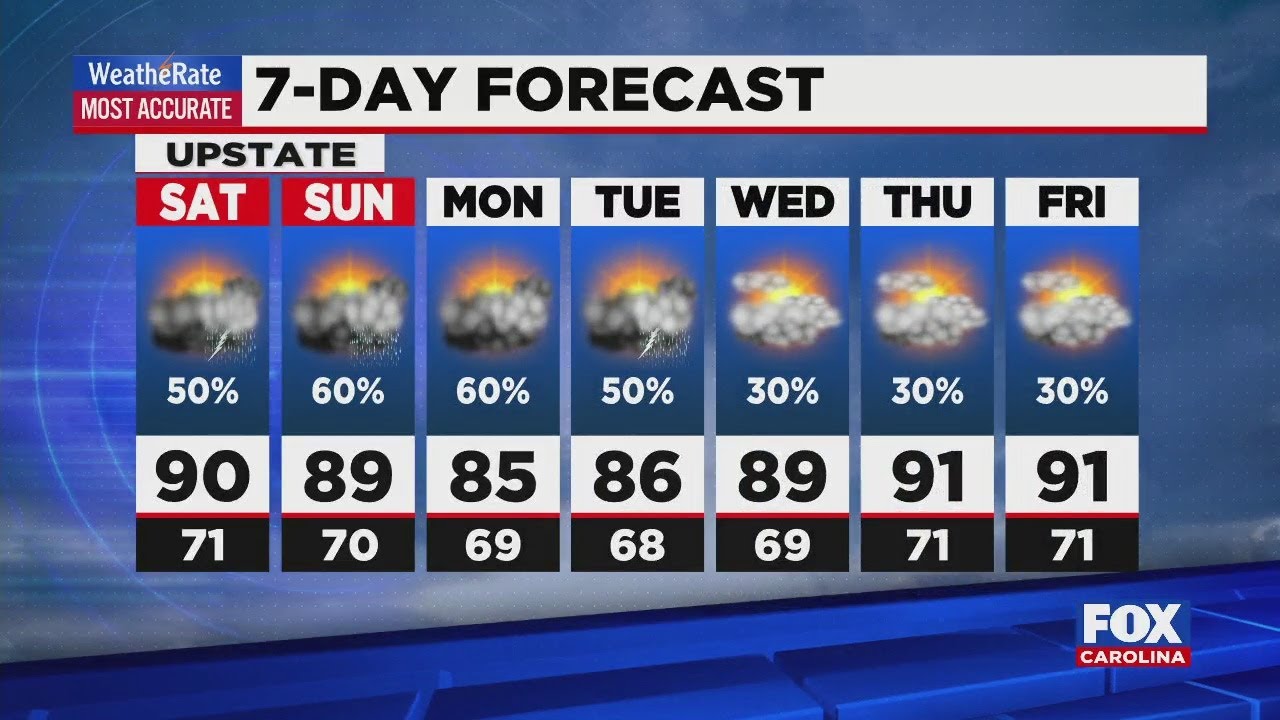
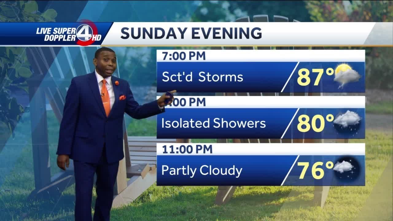
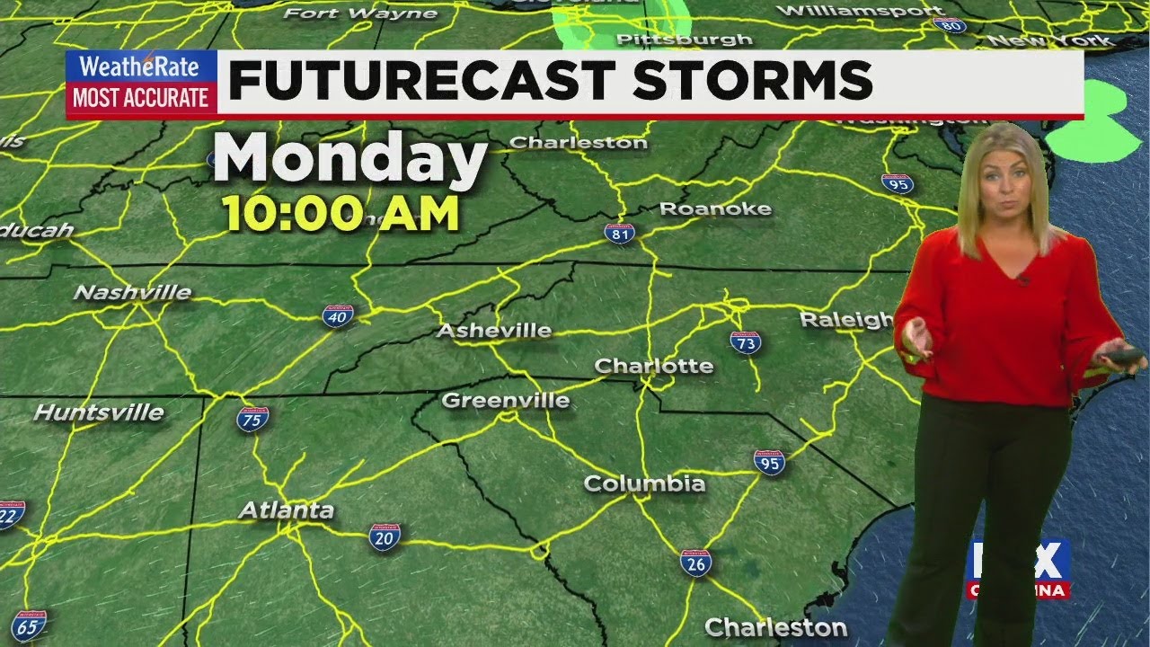
well, we got some isolated thunderstorms heading our way today with heavy rainfall, some gusty winds and also some cloud to ground lightning. Those will be the main concerns heading into today, tonight and even throughout the day tomorrow as we go into Saturday and Sunday, though, the rain will become more isolated and then attention turns toward next week, when we might have a remnants of a tropical system heading our way. Believe it or not. Right now, we’ve got three different systems that we’re tracking out in the tropics right now. A newly formed tropical depression 14. This was a tropical wave earlier today. Now it’s been upgraded to a tropical depression. We have tropical depression 13. This is the one that has the greatest chance of impacting us as we go into maybe Tuesday or Wednesday of next week. And then we have a tropical wave pretty close to Africa, not expected to impact anything over the next couple of days. But we might be tracking that when next week will keep you updated with that. Here’s tropical Depression 14 still projected to move out into the Gulf of Mexico. In fact, as it moves over land it loses a little bit of strength and then regains it, possibly heading into Texas or toward there as we go into Monday and Tuesday. Then we have Tropical Depression 13 which has its sights, also said on the Gulf, right around the same time, but becoming a Category one hurricane potentially Sunday night into Monday. So if both of these systems end up in the Gulf of the same time, that would be the first time that’s happened since June of 1959. That was the last time we had two systems active in the Gulf of Mexico. Pretty impressive, considering it is, of course, peak season, which is mid August through late October. So we’re just kind of hitting that peak. Ah, little closer to home and a little sooner, that is. Today we have a thunderstorm threat for basically all of our viewing area. So some of the strong storms that rolled through today have a chance of becoming severe with that main threat again being lightning, gusty winds and some heavy rain at times beginning to see a few thunderstorms firing up just south and along I 85 notices we go throughout the day today will seem or pop up, and especially tonight and even during the overnight hours, we will see some of these heavier bands of rainfall. That’s just 3 30 Tomorrow morning, you could see a couple thunderstorms rolling through starting, say, around Anderson Clemson Hartwell Toccoa area and then moving north into the mountains. At least that’s the way it’s been looking for most of the day that as we go into Friday afternoon, we have a couple of those heavier sell. Some of these could be slower moving, so possibilities were will have pockets of flooding that is also possible. And then we get into Saturday. The rain will become more isolated. It’ll be around and mainly focused in the mountains. But not nearly as heavy at times is what we are expecting today and tomorrow. Sunday rain is more isolated as well. Right now, Monday could actually be dry, which would be good. And then you see, as we head into Tuesday and Wednesday, there’s a little bit of a question mark because it all depends on the path of those storms out in the tropics. That one in particular tropical Depression 13 that could be heading our way with some remnants of rain will keep you updated
Advertisement
Videocast: Storms Today, Tropical Rain Next Week
Videocast: Storms Today, Tropical Rain Next Week
Updated: 11:47 AM EDT Aug 20, 2020
Videocast: Storms Today, Tropical Rain Next Week
Videocast: Storms Today, Tropical Rain Next Week
Advertisement