
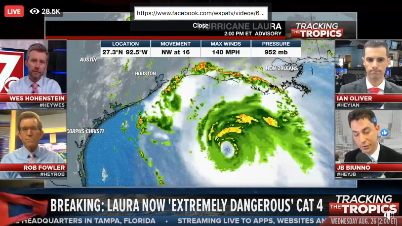
2pm Update From National Hurricane Center
CHANGES WITH THIS ADVISORY:
None
SUMMARY OF WATCHES AND WARNINGS IN EFFECT:
A Storm Surge Warning is in effect for…
- Freeport Texas to the Mouth of the Mississippi River
A Hurricane Warning is in effect for…
- San Luis Pass Texas to Intracoastal City Louisiana
A Tropical Storm Warning is in effect for…
- Sargent Texas to San Luis Pass
- East of Intracoastal City Louisiana to the Mouth of the
Mississippi River
A Storm Surge Watch is in effect for…
- Mouth of the Mississippi River to Ocean Springs Mississippi
- Lake Pontchartrain, Lake Maurepas, and Lake Borgne
A Hurricane Watch is in effect for…
- East of Intracoastal City to west of Morgan City Louisiana
A Storm Surge Warning means there is a danger of life-threatening
inundation, from rising water moving inland from the coastline in
the indicated locations. For a depiction of areas at risk, please
see the National Weather Service Storm Surge Watch/Warning Graphic,
available at hurricanes.gov. This is a life-threatening situation.
Persons located within these areas should take all necessary
actions to protect life and property from rising water and the
potential for other dangerous conditions. Promptly follow
evacuation and other instructions from local officials.
A Hurricane Warning means that hurricane conditions are expected
somewhere within the warning area. Preparations to protect life
and property should be rushed to completion.
A Storm Surge Watch means there is a possibility of life-threatening inundation from rising water moving inland from the coastline in the indicated locations.
A Hurricane Watch means that hurricane conditions are possible within the watch area.
A Tropical Storm Warning means that tropical storm conditions are expected somewhere within the warning area.
For storm information specific to your area, including possible inland watches and warnings, please monitor products issued by your local National Weather Service forecast office.


