
A low pressure off the South Carolina coast has seen it’s pressure begin to drop as the thunderstorms near it began to organize. Forecasters have hiked its chances of strengthening into a tropical depression to 60% and it is expected to bring rain to the South Carolina Coast late Monday. An Air Force hurricane hunter airplane is scheduled to investigate the system later this afternoon.
The current track of the system takes it south of Greenville and the Upstate but it appears that our area may get some rain as it tracks westward.
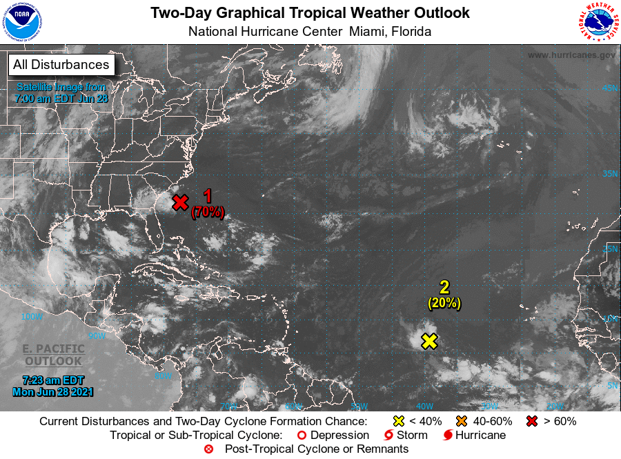
Latest National Hurricane Center Forecast
1. A well-defined low pressure system located about 190 miles east-southeast of Hilton Head Island, South Carolina, is producing a large area of showers and thunderstorms mainly west of the center. However, any additional increase in organization of the thunderstorm activity would result in the issuance of advisories for a tropical depression or tropical storm later this morning or afternoon. The low is forecast to move west-northwestward at 15 to 20 mph, and the system should reach the coast of southern South Carolina or Georgia by this evening. If advisories are initiated, then tropical storm warnings could be required for a portion of the Georgia and South Carolina coasts with short notice. Regardless of development, a few inches of rain are possible along the immediate coasts of Georgia and southern South Carolina through Tuesday. An Air Force Reserve Unit reconnaissance aircraft is scheduled to investigate the system this afternoon.* Formation chance through 48 hours…high…70 percent.
* Formation chance through 5 days…high…70 percent.
2. A broad area of low pressure associated with a tropical wave is producing a small cluster of showers and thunderstorms over the central tropical Atlantic Ocean. Some slow development is possible through the end of the week while this system moves quickly westward to west-northwestward at about 20 mph, likely reaching the Lesser Antilles Wednesday night.
* Formation chance through 48 hours…low…20 percent.
* Formation chance through 5 days…medium…40 percent.


