
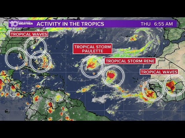
It is officially peak hurricane season! There’s no question that the tropics are churning out storms and tropical waves left and right.
In addition to two named tropical storms, Paulette and Rene, which you can find out more about here, there are multiple areas in the tropics that we’re keeping our eye on.
Let’s start to the waves closest to the United States.
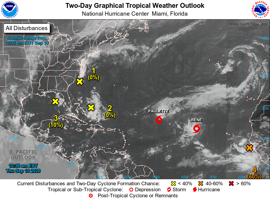
National Hurricane Center
National Hurricane Center Home Page
Latest NHC Forecast
For the North Atlantic…Caribbean Sea and the Gulf of Mexico:
The National Hurricane Center is issuing advisories on Tropical
Storm Paulette, located over the central tropical Atlantic, and on
Tropical Storm Rene, located over the eastern tropical Atlantic.
- A trough of low pressure located just off the coast of North
Carolina is producing minimal shower and thunderstorm activity.
This system is expected to move inland over eastern North Carolina
this afternoon, and therefore significant development is not
expected.
- Formation chance through 48 hours…low…near 0 percent.
- Formation chance through 5 days…low…near 0 percent.
- A large area of disorganized showers and thunderstorms centered a
couple of hundred miles northeast of the Central Bahamas is
associated with a surface trough of low pressure. This system is
forecast to move westward, crossing the Bahamas and Florida on
Friday and moving into the eastern Gulf of Mexico over the weekend.
Upper-level winds are expected to become conducive for some
development of this system while it moves slowly west-northwestward
over the eastern Gulf of Mexico early next week.
- Formation chance through 48 hours…low…near 0 percent.
- Formation chance through 5 days…low…30 percent.
- Another trough of low pressure has developed over the northeastern
Gulf of Mexico and is producing a few disorganized showers and
thunderstorms. Some slow development of this system is possible
while this system moves westward and then southwestward over the
northern and western Gulf of Mexico through early next week.
- Formation chance through 48 hours…low…10 percent.
- Formation chance through 5 days…low…20 percent.
- A tropical wave is now moving off the west coast of Africa,
producing a large area of showers and thunderstorms. Gradual
development of this system is forecast, and a tropical depression
is expected to form by this weekend or early next week while the
system moves generally westward across the eastern and central
tropical Atlantic.
- Formation chance through 48 hours…medium…60 percent.
- Formation chance through 5 days…high…90 percent.
- Another tropical wave is forecast to emerge off the west coast of
Africa this weekend. Environmental conditions are expected to be
conducive for development, and a tropical depression could form
over the far eastern tropical Atlantic Ocean early next week while
the system moves slowly westward.
- Formation chance through 48 hours…low…near 0 percent.
- Formation chance through 5 days…medium…40 percent.


