
Tropical Depression 14 is in the western Caribbean and it is still not very organized. It is battling some dry air and wind shear. It will continue to move NW across the NW Caribbean today and is forecast to become a tropical storm and eventual hurricane before landfall Saturday night on the Yucatan Peninsula.
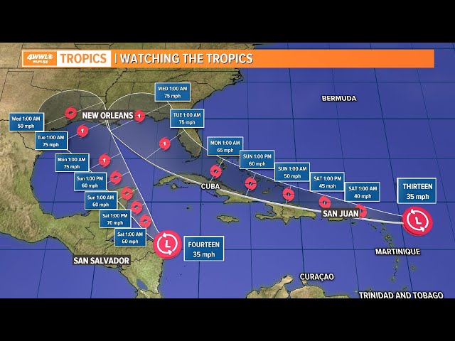
Tropical Depression 13 is poorly organized as it continues to battle some wind shear and dry air. It is tracking west just south of a ridge of high pressure located over the central Atlantic. It will continue to move west to WNW over the next few days and will be located near the northern Leeward Islands this weekend as a possible tropical storm (Marco). Then it will continue to track WNW just north of Hispaniola, Cuba and across the southern Bahamas. At this point it is expected to have favorable conditions to strengthen. If it stays over water it will have a better chance to get stronger as it moves toward the Florida Straits.
However, if it moves over the islands it will likely be much weaker. This is something we will have to closely watch this weekend. Once it passes the Bahama islands the forecast models show it moving across the FL Keys and into the Gulf of Mexico. It will be moving along the western edge of the Atlantic high pressure and this will help to turn it north in the eastern Gulf.
It is now forecast to make landfall Wednesday morning as a hurricane near Pensacola, FL. There is still plenty of uncertainty with this track and intensity of this system. Once it passes the Greater Antilles then we will have a better idea where TD 13 will track. Stay tuned.


