
11am NHC Advisory: WATCHES AND WARNINGS
CHANGES WITH THIS ADVISORY:
The government of Cuba has discontinued the Tropical Storm Warning
for the provinces of Guantanamo, Santiago de Cuba, Holguin, and
Granma.
SUMMARY OF WATCHES AND WARNINGS IN EFFECT:
A Tropical Storm Warning is in effect for…
- Little Cayman and Cayman Brac
- Cuban provinces of Camaguey, Las Tunas, Ciego De Avila, Sancti
Spiritus, Villa Clara, Cienfuegos, Matanzas, Mayabeque, La Habana,
Artemisa, Pinar del Rio, and the Isle of Youth - Florida Keys from Craig Key to Key West
- Dry Tortugas
The Tropical Storm Warning means that tropical storm conditions are
expected somewhere within the warning area, in this case within the
next 12 hours.
Hurricane and Storm Surge Watches will likely be required for
portions of the U.S. northwest Gulf coast area by this evening.
For storm information specific to your area in the United
States, including possible inland watches and warnings, please
monitor products issued by your local National Weather Service
forecast office. For storm information specific to your area
outside of the United States, please monitor products issued by
your national meteorological service.
DISCUSSION AND OUTLOOK
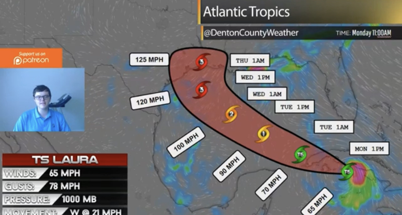
At 1100 AM EDT (1500 UTC), the center of Tropical Storm Laura was
located near latitude 21.2 North, longitude 80.6 West. Laura is
moving toward the west-northwest near 20 mph (31 km/h), and this
general motion with some decrease in forward speed is expected over
the next day or so. A turn toward the northwest is forecast by
Wednesday, and a northwestward to north-northwestward motion should
continued through Wednesday night. On the forecast track, the
center of Laura will move over the Caribbean Sea just offshore of
the southern coast of Cuba this afternoon, cross western Cuba this
evening, and move into the southeastern Gulf of Mexico overnight.
Laura is then forecast to move over the central and northwestern
Gulf of Mexico Tuesday night and Wednesday, and approach the
northwestern coast of the Gulf of Mexico Wednesday night.
NOAA and Air Force reconnaissance aircraft indicate that the
maximum sustained winds are near 60 mph (95 km/h) with higher gusts.
Little change in strength is forecast today, but strengthening is
expected when the storm moves over the Gulf of Mexico, and
Laura is foreast to become a hurricane on Tuesday, with additional
strengthening forecast on Wednesday.
Tropical-storm-force winds extend outward up to 175 miles (280 km)
from the center.
The estimated minimum central pressure based on reconnaissance
aircraft data is 1002 mb (29.59 inches).


